
A Solution to Why Amelia Earhart Didn’t Find Howland Island
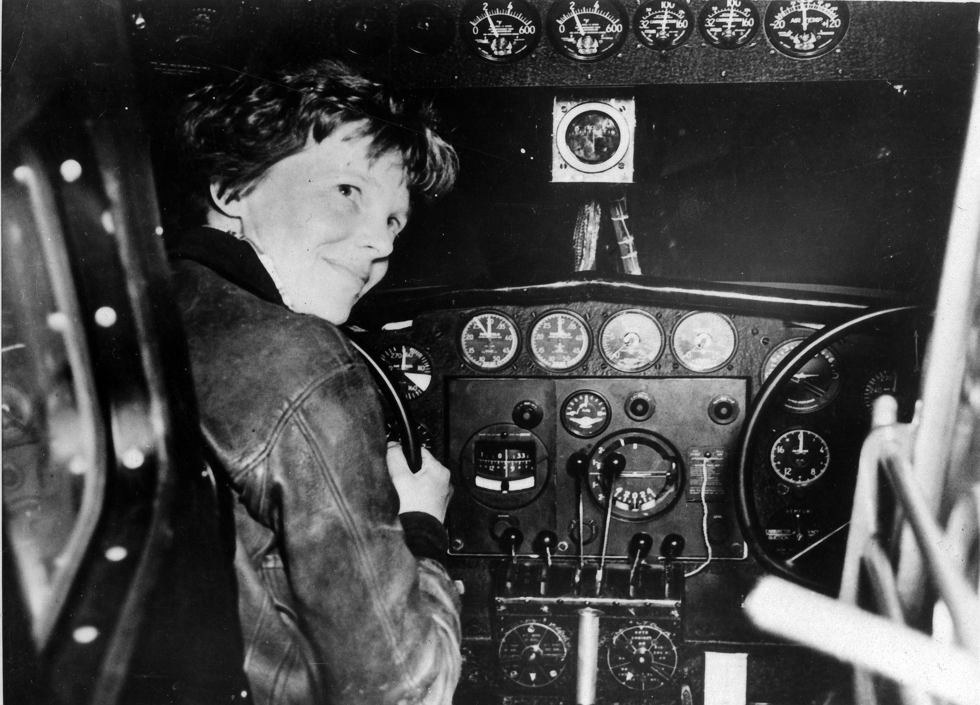
Amelia Earhart, a household name and one of the most recognizable figures in the 1930s, disappeared July 1, 1937 while attempting a challenging and lengthy flight from Lae, New Guinea, to Howland Island, a remote speck in the Pacific. The tiny, uninhabited island had only a dirt runway for her intended landing. The U.S. Coast Guard ship Itasca was stationed nearby to provide assistance. Earhart made radio contact with the Itasca but never located the island and was neither seen nor heard from again. Thus began a seemingly never-ending inquiry into what happened.
Little did she know that she left behind the perfect mystery, with only a handful of clues, each containing so little, yet so much.
The Short Version
In case you're new to this, here is the short version of what happened: Earhart thought the Itasca could take radio bearings on her (they couldn't), and the Itasca thought she would take radio bearings on them (she couldn't). Oops! Then she resorted to searching north and south along the 157° and 337° line (explained below), which in her mind Howland Island should be on (it wasn't). End of story.
West of Howland
She was somewhere west of Howland Island. And that is easily provable with some time—distance—speed arithmetic.
Just take the distance from her 0718z position report to Howland Island (1455 nm) and divide by the time difference until 1911z, when she thought she had reached Howland and radioed “We must be on you…” (11.9 hours), and you get a groundspeed of 122.3 nm/hour. At a maximum true airspeed of 130 nm/hour, the difference being the headwind; only 7.7 knots. Impossible.
That they only experienced 7.7 knots of headwind for almost 12 hours at 10,000 feet is inconceivable.
For example, the Itasca recorded winds all night of ~NE at 16 knots, and the ship Ontario at her half-way point recorded east winds at 11–16 knots, about the same as forecast. Everywhere within 1000 miles was forecasting or reporting winds between 10-20 knots from the east..
So, folks, let's quit assuming the line of position she last said she was flying, was correctly calculated through Howland Island. It was not—they could not possibly have gotten that far east in the time available. Earhart was somewhere to the west, probably 50-60 miles.
What is a line of position?
Her backup plan was to search for the island along a line of position (LOP) calculated by her navigator, Fred Noonan, from a celestial observation of the sun, which had risen about an hour earlier. Lines of position were the bread and butter of navigators in the 1930s, their charts were crisscrossed with LOPs everywhere.
LOP 101: One celestial observation with a sextant of a star or the sun gives you one LOP. A line on your chart that you are on somewhere. A second observation of a different star and you get another LOP from a different direction. Voila, where they cross is where you are.
In the daytime, there is only the sun, so only one LOP to work with. Earhart would have to search along the LOP for the island.
Explore this computer recreation of her flight for context. The map traces her journey from takeoff in Lae, New Guinea, to her search for Howland. Hover over elements to see their significance, scroll to view the full route, or use the full-screen button for a better look. The details of this simulation will be explained below.
To see the calculations performed for the magenta line in the map above, click here.Misplaced LOP
Since something called a line of position (LOP) is obviously central to this story, and there seems to be more than one, lets clear this up now with the help of the map above. Here is the sequence of events begining after almost 12 hours of night flying;
- Navigator estimates they are about 200 miles away from Howland Island and tells pilot. Pilot reports that by radio. (Marker 1)
- Navigator sees sky getting light and prepares to take sextant sight of the sun for one last position correction. Sunrise occurs (yellow line between marker 1 & marker 2.)
- Navigator uses sextant to measure the angle of the sun above the horizon.
- Navigator does complicated calculations and arrives at a line of position he can draw on his chart. in this case the line is oriented 157° and 337°
- Navigator has made some kind of mistake. The line is not where it should be, although 157 & 337 are correct. Everything hereafter is thrown off by this.
- Navigator draws line of position on the chart thinking he is on that line somewhere. (Not shown. Somewhere between sunrise and marker 2)
- Navigator sees that line of position crossed his course line almost perpendicular as expected, and deduces that (where they cross) is where he is.
- Navigator measures distance from there to Howland Island and it is somewhat closer than his last estimated position. Not a problem, that was the whole point of doing this, which was to accurately eliminate any east-west position error before getting any closer to Howland.
- Navigator advises pilot they are closer than expected, about 100 miles now. Pilot reports that by radio. (Marker 2)
- Navigator calculates the new estimated time of arrival (probably about 1900z) and tells pilot to maintain course and expect to arrive at Howland at that time. (Marker 2A)
- Navigator does what is called advancing the line. That is drawing a parallel line through where Howland Island should be. (Long white line.)
- Navigator thinks to himself. I am on the first line of position now, and at my ETA I will be on the second line through Howland. As a backup plan, we can always find Howland by flying up and down the 157° - 337° line.
- Pilot arrives at ETA and does not see Howland Island. Circles around a few minutes looking for it. Pilot picks up microphone and radios to the Itaska, "We must be on you, but cannot see you."
- Pilot unable to make two way radio contact with Itaska or take or get radio brearings. Resorts to flying the line looking for Howland. Does not find Howland because the "line" is misplaced west of Howland.
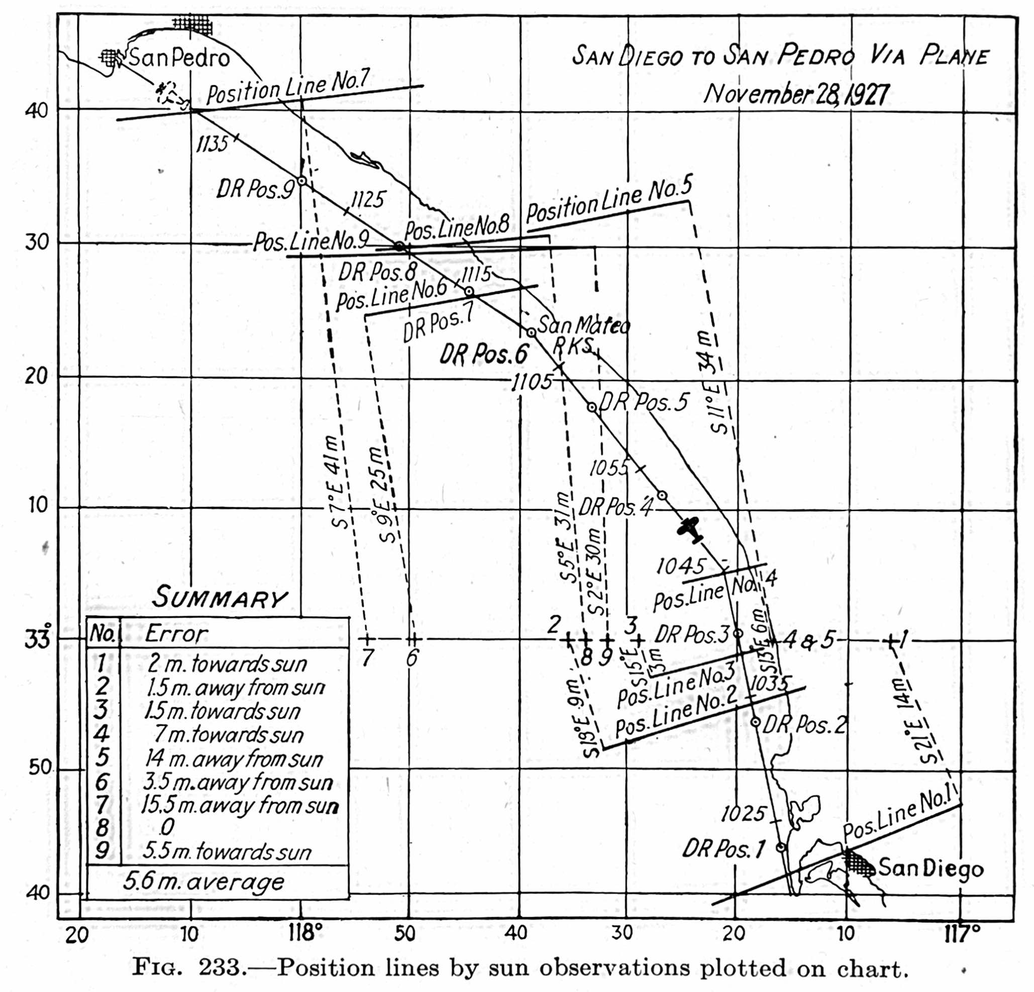
Here is a sample of what a navigators plotting of lines of position of the sun looks like. Note the error tally in the lower left. Most but not all were taken from the cockpit. This is from the textbook Air Navigation, by Weems, page 364, 1938 edition. Probably a training flight because you wouldn't do this many LOPs on such a short flight, not to mention all they are doing is flying along the coast.
200 Miles Out
At 1744z (Marker 1), Earhart makes a routine radio report and mentions that they are 200 miles out.
Based on the expected time-distance-speed since their last known position over twelve hours earlier, this is indeed about 200 miles from Howland.
100 Miles Out
At 1811z (Marker 2), just 27 minutes later, Earhart makes another radio report saying she is now 100 miles out.
These words have long baffled researchers because an Electra cannot fly 100 miles in 27 minutes. What happened between these reports to cause this inconsistency?
Sunrise at 10,000 Feet
Sunrise is what happened—at their 10,000' cruise altitude. Apparently, no one until now has made that correlation, and not surprisingly, because it takes extensive computer computations to predict when their progress at 10,000' east meets the sunrise progressing west. The sunrise is moving west at 900 nautical miles per hour, and they are traveling east at about 120 knots. Where do they meet?
The 27 Minute Window
As it turns out, with 100% certainty from the computer simulation, sunrise where the aircraft was flying, always occurs between the 1744z radio call saying they were 200 miles out and the 1811z radio call saying they were 100 miles out. This is true at any reasonable airspeed they were using and any headwind between 10–30 knots. This has been thoroughly tested in the computer simulation.
Such a broad claim may not seem possible, but the explanation is that sunrise is traveling west at a very fast speed—900 nautical miles per hour, 15 miles per minute. They were going the opposite direction at about 115 knots, a 1015 knot closing speed. So, regardless of whether they are an X number of miles closer or farther along, the sunrise is coming at them so fast the time of encounter does not change much and always falls well within that 27 minute window.
Think of it like walking down a train track when a high-speed train is coming at you. The time the train reaches your position doesn't change much whether you walk fast or slow and always occurs within a relatively narrow time window.
Last Fix
The significance of sunrise is that for Noonan a sextant measurement of the sun is his last opportunity to correct course, east and west mostly which would account for why their perceived position changed. He measured the sun, did some calculations and came up with a revised positon that was somewhat closer that his estimated position earlier. He advised Earhart of the update, and she reported that on the radio that they were now 100 miles out.
At this point, Noonan may have put away his things, leaned back, lit a cigarette and thought to himself, well my job is done, what a night. Little does he know, this last fix is way off for some unknown reason. Probably 50 miles to the west of where it should be. They would have been better off if they didn't do the sun sight at all and stuck with the original estimated position.
Earhart never actually has a two-way radio connection with anyone the whole flight. Mostly she just broadcasts these reports in the blind and radio opertors at various places are recording what she says in their logs. But she never seems to hear them when they call her back.
“We must be on you, but cannot see you”
Earhart's own words confirm the above.
When she radioed “We must be on you…” an hour after reporting being 100 miles out, she was indeed about 100 miles farther. (Marker 2A) To be exact, 115 nm, and she was clearly saying she thought she should be near Howland, confirming the previous estimate of 100 miles out if you allow for slight differences between these radio calls and what Noonan had plotted. Obviously, she got to where they thought Howland should be, didn't see the island, looked around a few minutes, then picked up the microphone and radioed, “We must be on you, but cannot see you.”
In reality, she was at least 50 miles west of Howland Island on what she thought was a valid navigational LOP through Howland Island. It wasn't.
Time—Distance—Speed
Wait, you say; all of the above presumes that somehow we know where she was when those radio calls were made. Correct. In other words, an accurate recreation of her time, distance, and speed since leaving Lae. A complete timeline where everything fits—no exceptions. We do.
Time
For making a timeline of where they were and when, at least the following known facts have to fit, and the closer the better:
- Departure from Lae at 0000z.
- At 0718z, Earhart reported her position as 4.33 south and 159.7 east and experiencing a 23 knot headwind. This is the only time for the entire flight, we have a sensible exact position with longitude and latitude.
- At 1030z, Earhart reported seeing a ship ahead. (This is almost certainly the Myrtlebank, which was known to be at longitude 167.1 east and reported hearing an airplane that night.)
- At 1744z, Earhart reported being 200 miles west from Howland.
Speed
We also need to know her true airspeed, but that isn't too hard to deduce. Noonan would have insisted on flying at a constant true airspeed—you just cannot do this kind of navigation any other way. That would most likely be 150 MPH. Why?
- It is in the general range of best long-range airspeeds which vary with aircraft weight..
- Anything less than 150 does not get them anywhere near Howland Island by 1912z. Anything more than 150 is less fuel efficient.
- At 0718z Earhart reported her position and 23 knots of headwind. That works out to exactly 150 MPH if you assume she meant average headwind until then.
- The numbers just work out in nice round numbers which Noonan would have liked. For example, at that true airspeed, minus a 15 mph headwind, the flight time to Howland is exactly 19 hours, and the true airspeed in knots is exactly 130 knots—nautical miles per hour being the unit of speed that navigators work in.
- Lockheed Aircraft responded to a Navy request stating the Electra speed would be 150 MPH in still air.
So, before the flight, he might have converted that into indicated airspeed in miles per hour (as her airspeed indicator worked in) and given her a slip of paper like this:
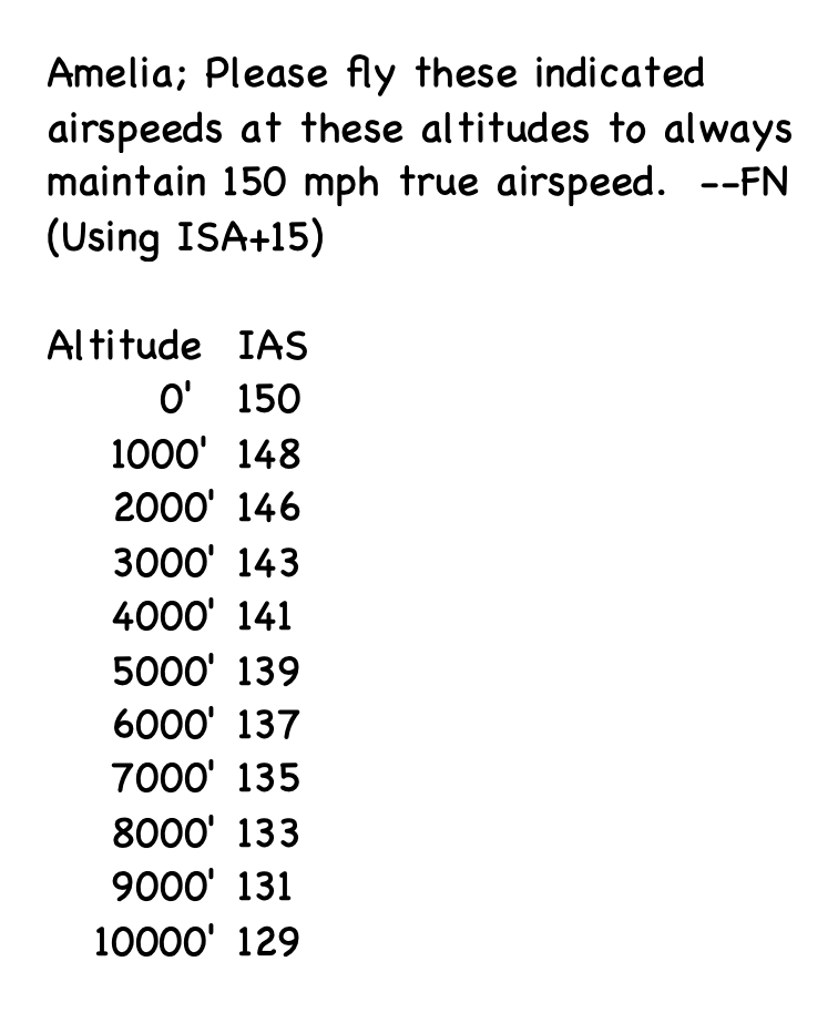
(Indicated airspeed on her airspeed indicator decreases with altitude because the air is thinner.)
Headwinds
Finally, we need to know the headwinds. (There are no tailwinds in June or July.) This may seem unknowable, but in this part of the world at that time of the year, if you forecast 10–20 knots from the east, you would rarely be wrong. In fact, the forecasts, which were at best educated guesses, and actual ship reports were all within this range.
But to be sure, using modern weather data available to this website through NOAA GRIB data updated four times per day, here is a graph of the above computer simulation run using real-time wind data four times per day, every day, in June and July for 2025. This shows the overall average headwind from takeoff at Lae to reaching Howland Island.
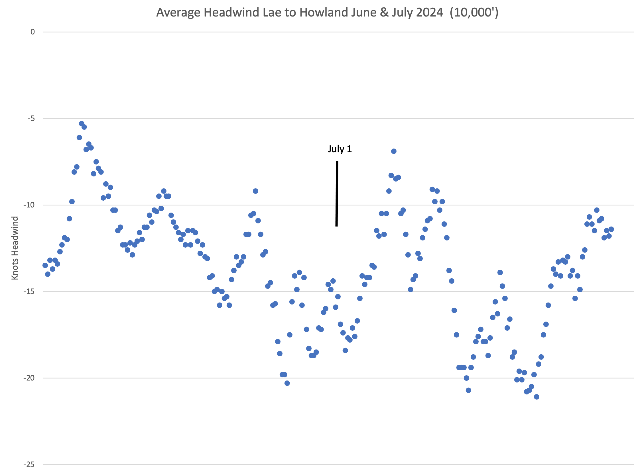
As you can see, you can't go very far wrong assuming 10-20 knots of headwind. This was also done for June & July of 2024 with similar results.
Just for fun, if you want to see today's real-time upper wind GRIB forecase for 10,000' on the map above, go to the layers box and click on Today's Winds. (Her flight was July 2, 1937, so unless you are looking at this in June or July, it might not be representative.)
Simulation Profile
So here is the flight profile used for the simulation:
- 150 MPH constant true airspeed from start to end.
- 23 knots of average headwind until the 0718z position report (as she reported).
- 12 knots of average headwind from the east thereafter because having 20 knots or greater for the whole flight doesn't agree with anything known, forecast, or tested with real-time winds for June & July. And the ship Ontario at her halfway point reported 11–16 knots from the east, and the Itasca reported 16 knots from the east all night. And her overall flight time to the 1912z radio call of “We must be on you” indicates an average headwind of about 17 knots for the whole flight.
(Sorry, but there is a lot of mixing of miles per hour and knots due to the Electra being designed using MPH and navigation being designed using knots. All modern aircraft now use knots as does software.)
Disclosure; I'm cherry picking the 12k headwind because it really makes things line up perfectly. It is a little on the low side but anything higher than this just puts them farther and farther to the west of Howland.
So what happens if you run a computer simulation using these numbers?
- At 0718z, she is exactly where she said she was having encountered 23 knots average wind since takeoff until then. This confirms that they were using 150 MPH true airspeed.
- At 1030z, she is within visual eyesight of the Myrtlebank. (see map)
So far, a good match. But then an ah-ha moment occurs, something very special.
At 1744z, when she reports 200 miles from Howland, the simulation agrees, she really is almost exactly 200 miles from Howland.
This was one of the most interesting discoveries of this project, was to find that this 200 nm distance matched up very near Howland. It appears until now, Noonan was very close with his navigation. But then things things begin to fall apart.
“Flying the Line 157-337”
First, a recap of some well-known facts. At 2013z, after an hour of searching for Howland, Earhart radioed that she was “flying the line 157–337,” and that was very telling in more ways than one.
It has long been known that those numbers are the exact directions perpendicular to the direction the sun rose on that morning. Earlier, when Noonan did his sun calculation, the line of position he drew on his chart would have been aligned 157° and 337° true (180° opposite on the compass and perpendicular to the sun). He also did what is called advancing the line, by drawing a parallel line running through Howland Island, knowing that when they arrived at their ETA, Howland Island had to be somewhere on this line in case they were off course. A backup plan if they had to search for it. (they did)
Later, her radio call saying she was flying the line confirms that they had resorted to searching for the island this way, flying north and south along this line hoping to find Howland Island on their own.
But 157° and 337° tell us a lot more. Noonan could only have come up with these values if he did his sun observation before 1846z, at which time the sun would have moved a degree in position (azimuth) and the numbers would be different (156° and 336°). And given that she changed her ETA dramatically at 1744z, he must have done it before then. This tells us at least a contributing factor to why it was so wrong.
That is not a good time to do sextant sights of the sun. The sun is not high enough for reliable sights. At her 1744z radio position update, the sun was only 5.3° above the horizon, meaning that its apparent height was being distorted by light refraction (bending of light as it passes through the atmosphere) that would throw off sextant observations. This is well known to navigators, and they have tables for correcting for this. But, as researchers have pointed out, the almanacs of 1937 did not have refraction corrections for below 6° since it was inadvisable to do such observations due to excessive errors.
Unlike mariners, Noonan did not have the time to wait for the sun to get higher. They were fast approaching Howland, and he had no choice. This would have been a grand oh-shit moment for Noonan for not having a critical piece of data he needed and not anticipating their arrival would be with the sun so low. Whatever he did to salvage this didn't work. The line of position was considerably wrong, at least 50 miles west of where it should be. (Marker 2A on the map.)
There is also the possibility the line of position was calculated by just observing the time the sun rose and calculating an LOP from that. The navigation books of the time do not document this procedure, but it is actually very simple, and a navigator of Noonan's ability could have easily figured it out on his own. Since the time of sunrise at Howland was known (1745z), this formula is all you need to calculate your distance from Howland:
\[ ( \text{Observed sunrise in minutes after the hour} - 45 ) \times 15 + \text{Distance to Horizon} \]This too has issues with refraction, but at least the tables for sunrise have the refraction already built in. Two things make this method unlikely: 1) To miscalculate being too close to Howland requires using an earlier time of sunrise, and it is impossible to mistakenly see the sunrise early; and 2) As reported by the Itasca, there was a bank of clouds to the northwest of Howland that possibly obscured seeing the sun peek above the horizon.
Noonan's World at Sunrise
That Noonan miscalculated the line of position is possibly explained by the inappropriate low angle of the sun that he had to work with and lack of data to correct for that. But it gets worse.
First, to use his sextant and see the sun, he would have had to go forward and do the sextant sight from the right-side cockpit seat, since the sun was ahead and slightly to the left. Normally, he would have done this from the specially made observation window that was purposely installed on the port side of the aft cabin. From the cockpit, he is sighting through the cockpit windows, which are optically imperfect and sloped, which can induce at least minor errors in the sextant measurement but not enough to throw things off this far.
Second, the elephant in the room, which to date has not been discussed by researchers: hypoxia compounded by fatigue. By the time of sunrise, Noonan had been up over 24 hours and deep into the body's circadian low period in the hours before sunrise.
It doesn't take a scientist to tell you what this is like; just try it for yourself—go camp out on a high mountain, stay up all night, and then do complex arithmetic. See how that works for you.
Any pilot, like myself, can tell you that on long overnight flights, it is all you can do to stay alert in the hour or two before sunrise. Noonan had done this many times before and likely was being extra careful. But the lack of oxygen causes debilitating hypoxia, which in mild occurrences is undetectable by people.
Wait, you say, they were only flying at 10,000 feet—not high enough for hypoxia.
Well, yes and no. In modern times, the FAA has implemented regulations requiring pilots to use oxygen when flying above 12,500 feet for over 30 minutes and recommends oxygen when at 10,000 feet. For good reason, because they have the data to prove it. For example, a study by the FAA in 1997 found a measurable decrease in performance and increases in pilot errors after only 2 hours at 10,000 feet. Modern airliners are required to keep a cabin altitude below 8,000 feet, and some, like the 787 Dreamliner, keep a 6,000-foot cabin.
By sunrise, Earhart and Noonan had been at or above 8,000 feet for over 17 hours, and at 10,000 feet for probably ten hours.
It is hard to imagine a worse time to be doing complex celestial calculations.
The Plan That Wasn't
Noonan undoubtedly knew his line of position calculation was flawed. Taking celestial measurements at such low sun angles went against everything he knew. But so what, he thought—it was all he could do, and he only had to get them in the vicinity of Howland, and Earhart would be guided to the island by radio bearings.
That was always the basic plan. She even began calling the Itasca at 1744z for radio bearings before the sun had even risen.
Not As Simple as 157° and 337°
If you are under the impression that she merely turned to either 157° or 337° on her compass, it isn't that simple.
First, in that part of the world in 1937, the magnetic variation (compass deviation from true north) was 9.5° east, about the most anywhere in the world. Thus, on her magnetic compass in the cockpit, she would have to subtract 9.5° from each of those line-of-position true bearings, so the magnetic heading then becomes 147.5° and 327.5°.
One more thing: in order to track the line, she would need to adjust for the crosswind from the east. Guessing 15 knots from the east at 130 knots airspeed, that would be about 6.5° of correction. So, add that correction when heading northerly and subtract that correction when heading southerly. Now we have 141°– 334° that Earhart should be seeing on her compass when she said “flying the line 157-337”.
Get the picture? Presumably, Noonan could have or should have done this arithmetic for her, but as you can see, the opportunity for errors is ripe.
Interestingly, 334° is fairly close to the line-of-position value of 337°, since the wind correction cancels some of the magnetic variation, but in the other direction, 141° is far from the line-of-position value of 157°, since the wind correction is in the opposite direction.
Corrections for magnetic variation and wind drift are everyday things for navigators and pilots alike. But in the fog of fatigue, confusion, and anxiety of not finding Howland, whether all this got done correctly bears consideration.
This raises an interesting question. When Earhart radioed that she was flying the 157–337 line, did she mean that literally? Hopefully not. Up until then, those numbers were only needed by Noonan and weren't known or important to Earhart.
Ideally, Noonan would have done the calculations and told her that in order to fly the line of position she should use 141° or 334° and not risk confusion with useless details about the actual line-of-position true values. Or maybe I don't give them enough credit, and Noonan was by then in the cockpit, both actively engaged with finding Howland and exchanging all they knew with each other, desperate to find the island.
If you draw on a chart any combination of the above potential errors and where it leads, you won't like what you see. Basically, just wide-open ocean until fuel exhaustion.
What if they were simply off course?
Well historically, this has been the logical cause of not finding Howland. After all, by any measure it is a tiny-tiny target to find after an extremely long ocean crossing. Technically, a heading error of only a degree or two is all it takes. For a long time, I subscribed to this theory myself.
But their position report of 0718z is dead on course, as it should have been because at that point it was daylight and there were ample opportunities to spot landmarks and correct course. At 1030z Earhart reported spotting a ship, undoubtably the Myrtlebank whose position was roughly known and very near her course. Likewise the Myrtlebank reported hearing a plane and given the approximate 15 mile range an Electra could be heard, that puts them on course there too. Unconfirmed reports of an airplane being heard that night over one of the Gilbert islands (see map above) also lends credibility to being on course.
Most importantly, throughout the night Noonan had ample opportunity to take star sights out the north facing port side window he had just for this purpose. Yes, there were clouds at times that might have prevented this, but not all night. Night on the equator is almost 12 hours long. To long to not at times be able to get sextant sights of the stars. That was his one and only job all night and star sights were his bread and butter. That's what navigators of that era did and he had done it many times before. I can't imagine that he failed to get at least a few sights which would have easily let him make course corrections and keep them within 10 miles of course, probably less.
Failing to have celestial corrections all night would have surely caused Earhart to say something more dramatic than just “partly cloudy” like she radioed at 1623z about an hour before sunrise. Being unsure of your position by then would have been cause for major concern, not just “partly cloudy”.
That Noonan had the 200 mile out estimated position so close, lends credibility that he also had them pretty close to being on course as well. That is what I believe.
Being off course to some degree in this kind of navigation is a given. But in the end, whether or not you are on course is irrelevant, if you have the LOP completely wrong.
Spaghetti Archive
To test if there was any possibility that some kind of unusual wind could have pushed them off course or something, I devised a computer simulation where the flight takes off from Lae and navigates solely by holding the rhumb line course from there to Howland Island. For the wind, I used the actual winds of the day for 10,000 feet as provided by NOAA GRIB wind model.
First and foremost, there is no ‘navigation' in this—just holding a constant heading to see what happens as a result of the wind. The flight is calculated in 30 minute intervals and then updates the wind being used from the GRIB data. So, there is no one wind direction/velocity; it is whatever the GRIB model has for that day, that time, that latitude and longitude.
This simulation runs four times a day in sync with new GRIB data available from NOAA. It has been running every day of the year since 2024 and is still running every day.
I have selected the track results from just June and July of 2024 and 2025 and displayed all of them at once in what I call the Spaghetti Archive (of past test runs). Go to the layer control on the map above and click on the Spaghetti Archive layer to bring it into view.
As you can see, the flight almost always gets blown off course to the north of track due to the typical slight right crosswind of E to SE at 10–20 knots. Not very surprising, actually. No freak winds, no large excursions, just typical trade winds. So, if you have an Earhart theory and what became of her, and it involves getting blown off course to the south—sorry, no data here to support that.
Keep in mind that these tracks are uncorrected in any way. As you can see, many are too far from Howland to be within sight of the island, and that is to be expected. No one is ever going to try this by just holding a heading on a flight this long. That is why Noonan was there. This is just a demo to show the absolute worst case of being blown off course.
Heading Error
I considered the possibility of accumulated errors due to precession of the gyro compass, but precession at the equator is almost zero.
Maybe the gyro was defective. After all, they did have it worked on in Lae. (I shudder at the thought of having my gyro worked on in Lae in 1937). But so what if it drifts, just reset it more often.
In my youth as a cargo pilot, I hand-flew a Beech D-18 (a smaller version of the Electra) cross-country for hundreds of hours using just heading. We never flew over a VOR but would take VOR bearings to cross-check position. Once you get the hang of it, it works surprisingly well with only minor corrections. In an analog world, the errors to the left tend to cancel the errors to the right. You're just droning along for hours and hours with nothing much else to do but stay focused on the DG, check it against the compass frequently, and reset as-needed. As-needed is an understatement. Like a lot of war-surplus airplanes, my DG was old and drifted a lot. So we reset it more often and overcompensated knowing the excessive drift.
Earhart had a Sperry semi-autopilot that did most of the heading-holding work. By Lae, Earhart had been doing this most of the way around the world. Despite my misgivings about Earhart's aeronautical abilities, I think by then she was probably pretty darn good at holding a heading.
The fixer for any off-course heading error theories is always the fact that a good-quality magnetic compass is right there in front of her. You can see it top center in the picture at the beginning of this web page. And it appears from the Luke Field crash inventory that Noonan had one of his own too. More important, Noonan could fix any heading errors with just one or two star sights, and he probably was doing sights constantly through the night. It only takes about ten minutes each.
They both knew this was their longest, most challenging flight. By this point, two thirds of the way around the world, they were well seasoned and at the top of their game. That Noonan was not actively engaged all night doing what he could to keep them on course seems inconceivable. I have tried hard to come up with some kind of heading mistake explanation for this, but nothing withstands even a little scrutiny and personal practical experience.
Bingo
Bingo or Bingo Fuel is a term military pilots use to say they have reached the fuel level that they must quit the fight and return to base or ship. Let's consider how Earhart might of done something similiar.
It is has been reported that Eugene Vidal, a close friend of Earhart, said that she told him her plan was to search for Howland one hour and if they didn't find it to turn around and go for the Gilbert Islands. Saying "They are a long chain of islands and you can't help but find at least one". This seems like a sensible plan. Vidal and Putnam, Earhart's husband, even lobbied President Rosevelt to do a more through search of the Gilberts. (Rosevelt agreed to this.)
Here is a scenario of how this might have played out for them;
- After realizing they wern't going to find Howland by radio bearings, they resort to flying north and south on the line of position. That was her last radio transmission "We are flying the line 157-337".
- So, given an hour that would be 20 minutes north, backtrack 20 minutes, then 20 minutes south on the line. One hour.
- Bingo time. Actually past because they didn't immediately start flying the line. The seriousness of this moment is beyond description. This is life and death now.
- Earhart says to Noonan, "That's enough! I give up. This damn island isn't here. Let's go for the Gilberts."
- Fred has already been thinking about this and says "Amelia, from here, where ever we are, the Gilberts are 400-500 miles. I don't think we have enough fuel."
- Amelia stares hard back at him and says; "Fred—get us to the nearest land and I don’t care where!"
- Fred says, "The Phoenix Islands are about 300 miles south. Stay on this heading for now and I'll go back and do another sun sight and get you a course there." Earhart slowed the plane to the maximum range speed, which by now at the light weight, was somewhat slower that the 150 MPH she had been using. Speed didn't matter now, only range.
- By now, the sun is high in the sky and on a southerly heading Noonans observation window is well positioned for a first class sun sight with his sextant.
- The sun has also moved some in azmuth, so this new line of position is oriented 152-332. He plots it and where does it just happen to lead? Gardner Island.
- It is a real decent sized island and the closest of the Phoenix Islands, not a tiny speck like Howland. So that's it. They decide to run for Gardner and hope they have enough fuel.
To see how this would look on the map above, go to the layers control and click on the Bingo Fuel layer.
If they ended up on Gardner Island, it wasn't by accident, it was their only choice. And along the way, Noonan had excellent conditions for more sun sights—he was fighting for his life. Upon arrival at Gardner, they didn't have to look for it, it was dead ahead.
Conclusion
This concludes my presentation of why I think Amelia Earhart did not find Howland Island by the line of position technique, and that is all I claim to know. That is, they were likely not too far off course, but that was irrelevant because the line of position was misplaced too far to the west due to the sun being too low for Noonan to do accurate calculations, compounded by fatigue and hypoxia.
If they had departed Lae an hour later, Noonan could have gotten a proper sun sight later in the morning and a proper line of position fix, and they would have likely found Howland Island.
P.S.
There is a popular theory that Earhart landed on Gardner Island on a particular section of reef that is dry at low tide. My timeline above puts them there at a later time when the tide would have risen on the reef considerably.
As a pilot myself (and sailor) I thought; hey, if I'm flying overhead how do I know if the water is 4" deep or 12" or what? From the air, the clear Pacific water is impossible to judge how deep it is, especially for a pilot from Kansas (Earhart). And if there is any water at all, how would you know it is smooth coral underneath to land on? Coral reefs are not known for their smoothness. Earharts expertise on such things was probably just; Reef—bad, land—good.
Me too. I didn't come all this way to land on water. I'm going to land on land and I see lots of sandy beaches. The Electra with those big tires could have easily landed on a beach. And as empty on fuel as they were, probably a touchdown speed of only 60 knots. Things slow down fast on soft sand, so 500-1000' landing roll is all. Earhart was already experienced at walking away from crashing the Electra. A beach is guaranteed life to live another day.
So I studied Gardner Island in Google Earth and challenged myself to pick exactly where I would land if in her situation.
I picked my ideal beach stretch and did my imaginary landing. Then I zoomed in (with Google Earth) and took a closer look at the beach and nearby shore where I'd chosen to land. Inland, not far, I found things of that didn't look natural. Light colored or grayish objects that didn't match the terrain. Objects with straight edges, right angle corners or regular curves. But no airplane. After looking and looking for several days I was tired, leaned back in my chair and quit trying to focus on every little thing. Then, when I quit trying so hard, I saw the blurry shapes of two unmistakable oval shaped Electra rudders. Could it be?